|
Bowdon lies in the north east of Cheshire, half a mile or so from Altrincham and
about 13 miles from the centre of Manchester. Once a self-contained village close
to the Roman road between Chester and Manchester, it is now a part of Altrincham,
itself part of Greater Manchester. To the north and east is the Manchester conurbation,
to the south and west the Cheshire plain. In the early days of the Royles Bowdon
parish covered a very large area including Altrincham and several other surrounding
villages. This is where many of our ancestors were born, baptised, lived, served
as agricultural labourers, died and are buried. Coincidentally one of the last of
this branch of the Royle line still resides in Bowdon.
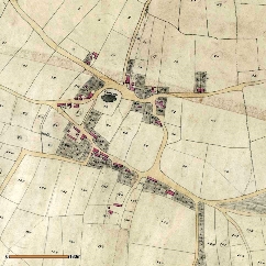
The upper map on the right shows the village as illustrated on the 1838 tithe map.
Just above the centre is the original church which was rebuilt around 1860. Many
of the Royle gravestones which can be found here predate this re-development; where
we have been able to photograph those relevant to our branch of the Royle family
we have included the images on the relevant pages. It is clear that the area was
agricultural so it is no surprise that many of the ‘early’ Royles were ‘gardeners’
(a term used for anyone who worked on the land). During the 19th century the whole
area, especially neighbouring Altrincham, developed rapidly as an agricultural centre,
whilst the coming of the railway after 1845 gave it much improved access to Manchester
and beyond.
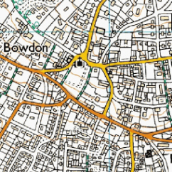
The second map, from the Ordnance Survey ‘Get-a-map’ service, shows the same area
today: the scale of the two maps being similar. Bowdon is now but a small part of
the conurbation even though its centre still retains reminders of its independent
past.
The Imperial Gazetteer of England and Wales (1870-72) describes Bowdon as follows:
“BOWDON, or Bowden, [is] a village, a township, and a parish in Altrincham district,
Cheshire. The village stands on the Roman road from Kinderton, [and is] adjacent
to the Manchester, Knutsford, and Northwich railway, near the river Bollin, ¼ of
a mile SW of Altrincham; and it has a station on the railway, with refreshment rooms
and telegraph, and a post office under Manchester. It enjoys fine air and charming
environs; and is a favourite resort of ruralizing [sic] parties from Manchester.
The township includes the village, and comprises 828 acres. Real property, £14,322.
Pop. 1,827. Houses, 301. The parish contains also the townships of Altrincham, Baguley,
Timperley, Hale, Ashley, Dunham-Massey, Carrington, Partington, and Bollington. Acres,
17,971. Real property, £90,900. Pop. 14,822. Houses, 2,779. The property is not much
divided. The manor belonged to the priory of Birkenhead; and was given by Henry VIII
to the see of Chester. Dunham Park is the seat of the Earl of Stamford, and has fine
grounds. The living is a vicarage in the diocese of Chester. Value, £460. Patron,
the Bishop of Chester. The church stands on elevated ground [and] was rebuilt after
the model of the previous one in the later English style in 1860 at a cost of about
£12,000 and comprises nave, chancel, aisles, transepts, chapel, and vestry, with
a tower. The p. curacy of St. John is a separate charge, constituted in 1866. Patron,
the Bishop of C. The church was completed in 1867, at a cost of £5,350 and is in
the early English style and cruciform. The chapelries of Altrincham, Carrington,
Dunham-Massey, Ringway and Timperley are separate benefices. There are numerous dissenting-chapels,
numerous public schools, and charities...”.
|
|